Places that have gone, or changed beyond recognition
Every village loses things. Somerton has lost a castle, a manor house, a hamlet, a station, a pub and a wharf, and has replaced its village hall. This page brings those places together, with where they were, what happened to them and what you can see today. Each entry links to the chapter that tells its story in full.
Each entry is labelled to show what kind of loss it is: a building demolished; a building that survives with a different use; a ruin; an archaeological site, known from earthworks or excavation; or a place whose site is unknown. Artist's impressions are reconstructions, and are labelled as such. We have not used any picture that pretends to be an old photograph.
Demolished
Somerton station
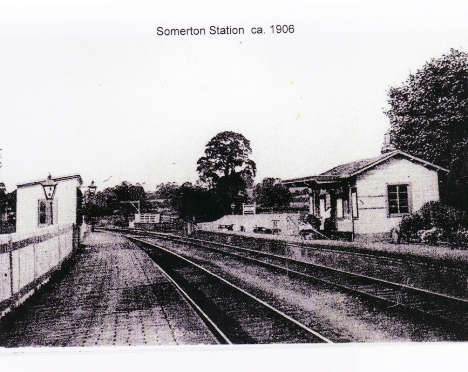
Somerton station around 1906, showing both platforms. Photograph from the Somerton Village History Project collection.
Where
Beside the road to North Aston, just before it passes under the railway, up on the left.
What happened there
Lord Jersey agreed to let the railway cross his land on condition that Somerton had a station. It opened in September 1854, a simple wooden building, with one siding, a cattle dock and room for the coal merchant. In 1907 it was renamed Fritwell & Somerton, after a station opened at Somerton in Somerset in 1906. Twelve trains a day still stopped right up to the end.
What changed, and when
The station closed on 31 October 1964, in the Beeching cuts.
Today
The railway is still in use, but trains no longer stop and the station has gone.
Read more: The Railway. Sources as given on that page, including the memories of Albert Fox.
Surviving building, now a home
The Railway Inn
Where
At the bottom of Water Street, opposite the station.
What happened there
An eighteenth-century stone house, once the home of James Jennings, the surveyor who drew the 1765 enclosure map. It was the village pub, the Railway Tavern or Railway Inn, from at least 1852, when John Collinridge was victualler, farmer and brewer there. The Waltons kept it from the 1890s to at least 1919, when it was sold with the wharf and Wharf House.
What changed, and when
It closed as a pub in the 1960s. We do not yet know the exact year, or who kept it last.
Today
A private house. Please look from the road only.
Read more: The Railway, which lists the landlords we know of. Sources: Gardner's Directory, 1852; Kelly's Directories; the 1919 estate sale; Cherwell conservation area appraisal; Valley News, August 2019, p.15.
Buildings demolished, site redeveloped
The wharf and the paper yard
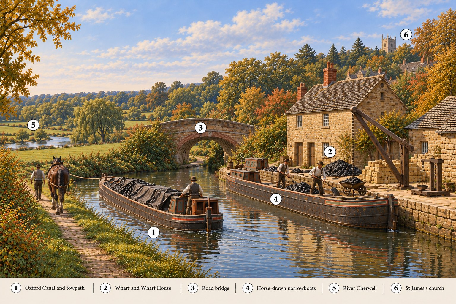
Reconstruction, not a photograph. Somerton Wharf around 1840, an artist's impression made in 2026 with an AI image tool from information provided by Della Paviour. No picture of the working wharf is known.
Where
Beside the canal bridge on the road to North Aston, just past the railway.
What happened there
The Oxford Canal opened past Somerton in 1787, and the wharf was the village's link with the wider world until the railway came. In 1919 the wharf and Wharf House were sold with the Railway Inn. By the early 1990s the wharf was being used to collect waste paper and pack it into large bales for recycling. This was a paper-recycling yard, not a paper mill, and it has nothing to do with Somerton Mill on the river.
What changed, and when
The Somerton Canal Cruising Club, formed beside the wharf in early 1993, records that the owner of the business later retired, the buildings next to the bridge were demolished, and three cottages were built. A 1998 sales brochure for "The Wharf", listed in the Oxfordshire History Centre's index of sale catalogues with Beaufort Homes as agent or developer, describes a "new development" of three canalside houses. We have not seen the brochure itself. We do not know who ran the paper business, or when it stopped.
Today
Three houses beside the canal bridge, with the club's moorings just to the south.
On the Heyford Road, where the Barnes Memorial Hall stands now.
What happened there
The Barnes Memorial Hall was given by the widow of the Reverend George Barnes, rector for 48 years, and opened by the Dowager Countess of Jersey on St George's Day, 23 April 1924. For over eighty years it held whist drives, dances, the produce show, parish meetings, polling day and the Social Club.
What changed, and when
By the 2000s the old hall had subsidence and a leaking roof. With a Big Lottery Fund grant of £311,000, awarded in December 2008, it was replaced by a new timber-framed hall on the same site, which opened on 17 April 2010.
Today
The new hall, whose gabled roof echoes the old one. Mrs Barnes's dedication plaque still hangs inside.
Read more: The Village Hall and the Social Club. Source: "Barnes Memorial Hall: 100 years of history", Valley News, December 2024, p.18. We do not have a photograph of the old hall. If you do, please send us a copy.
Ruin
The Fermor manor house
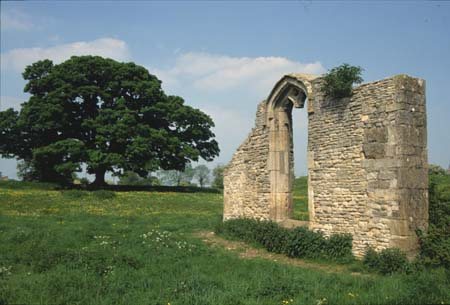
The west wall of the hall, with its great window: all that stands of the manor house. Photograph: Della Paviour.
Where
In the field east of the Heyford Road, behind Fermor House. A footpath passes it.
What happened there
William Fermor built a manor house here from 1512, and the Fermors held Somerton for three centuries. The house had a hall, a great parlour, two wings and a chapel, and 22 hearths in 1665. The chapel was still used for Catholic services in 1738.
What changed, and when
The Fermors moved to Tusmore in 1625. By 1738 the house was "almost ruinous", and later in the eighteenth century it was pulled down and much of its stone taken to build the new house at Tusmore.
Today
One wall and its window stand in the field, and the outline of the house and its garden banks can still be traced.
Read more: The Fermor Family, which has an artist's impression of the house around 1580, clearly labelled as a reconstruction, and The Manor. Sources as given on those pages.
Archaeological site
Somerton's "castle", Castle Yard
Where
Castle Yard, between the fishpond field and Water Street, by the Old School House.
What happened there
Not a castle with a keep but a defended manor house: a walled or stockaded yard with a stone hall, a dovecote (listed in 1295) and a chapel. It probably dates from the eleventh to thirteenth centuries. Graves found beneath the school in the nineteenth century, and twelve more in 1953 and 1969, some with a slab of limestone over the skull, suggest a burial ground in use before or soon after the Norman Conquest.
What changed, and when
In 1580 Thomas Fermor left the old chapel to become the village school. The Old School House is said to stand on the spot.
Today
Nothing of the castle stands above ground. A public footpath crosses Castle Yard; the houses beside it are private.
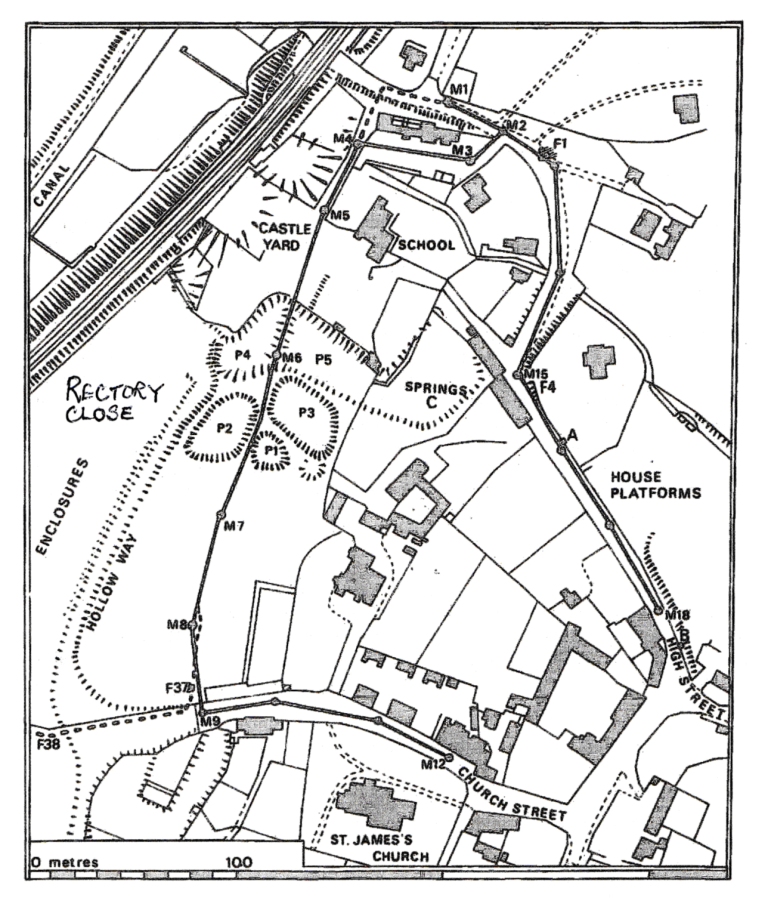
R. A. Chambers' plan of the earthworks, from his report on the 1973 excavations (Oxoniensia, 1977): the fishponds P1 to P5, the hollow way and the house platforms.
Where
Rectory Close, the field below the Old Rectory, and Grey's Close below Church Street.
What happened there
In the Middle Ages Somerton was larger than it is now. A sunken lane, the hollow way, ran through this ground with a row of houses along it, and below the castle lay a chain of fishponds, probably the ones listed in a survey of the manor in 1295.
What changed, and when
We do not know when these houses were abandoned.
Today
The bumps and hollows of the lanes, house plots and fishponds survive as earthworks. The public footpath from Church Street to Castle Yard runs along the causeway between two of the ponds.
Read more: Archaeology & Castle Yard, which has an artist's impression of this view around 1300, labelled as a reconstruction, and the village trail. Source: R. A. Chambers, Oxoniensia, 1977.
Site unknown
Northbrook
Where
Somewhere in the parish. Nobody has found it.
What happened there
Domesday Book records a settlement called Northbrook alongside Somerton. Later records speak of "the part of the vill of Somerton called Northbrook", and of two carucates "in Somerton and Northbrook" held by the Arsic barony.
What changed, and when
By 1220 Northbrook was being counted in with Somerton, and after that it fades out of the records.
Today
The Victoria County History calls its site "unidentified", and it still is. If you know of earthworks or field names with "Northbrook" in them, please tell us.
Read more: The Norman Period. Source: M. D. Lobel (ed.), Victoria County History of Oxfordshire, vol. 6 (1959), Somerton, a later account; the medieval documents it cites have not been seen.
Places we would like to add
We know these existed, but we do not yet know enough about when they closed or what replaced them:
The post office, shop and bakehouse, opposite the church, kept by the Baldwin family from at least 1895 to 1919. When did it close?
The Methodist chapel at the end of the row at The Paddock, recorded in 1910 and 1919.
The reading room, listed in the 1910 valuation survey on the Earl of Jersey's land, site unknown.
The village school, which closed at some point after 1951. We would like the date.
Thomas Moore's butcher's shop on the Fritwell Road, and the carpenter's shop and timber yard at The Paddock.
The old play area at the old sewage works, with equipment built by local farmers, taken down in the 1990s.
If you have photographs, dates or memories of any of these, or of the places above, please use the form below or see Can you help?
Share a memory or correction
Did you grow up in Somerton, or does this article bring back a memory? Do you spot something that needs correcting or adding? Rosemary Arnold and Della Paviour would love to hear from you.