In 1973 when mains drainage was installed in Somerton, the pipe-work from the bottom of Church Street was taken across Rectory Close (below The Old Rectory) to join the other pipe-work at the pumping station at the bottom of Water Street. As there had been some previous excavation work carried out at the school and its surrounds, two members of the Oxfordshire Archaeological Unit came to record any findings from the trenches that were being dug, and to reappraise the Castle Yard area. One of them – R A Chambers – wrote a paper on the findings, with a general overview of the village’s history and its topography.
Somerton was considerably larger in the Middle Ages than it is today, and Rectory Close is the site of a deserted part of the medieval village and the remains of medieval fishponds. A little further to the North is the area known as Castle Yard. It would seem that any Somerton castle, probably dating from the 11th to 13th centuries, was probably a simple walled or stockaded enclosure, perhaps beginning with a small motte, and subsidiary to the major castle at Deddington, built by order of Bishop Odo of Bayeux.
The most interesting finds during the 1973 excavations were made in the trench crossing the grounds of the Old School House – along the line of the public footpath – in Castle Yard. In particular, substantial evidence of human burials was found in what would seem to be the cemetery within the castle precincts. The graves varied from shallow to deep inhumations and at least some were in wooden coffins. Many can be related to the 16th century Roman Catholic chapel (which was bequeathed as a school in 1580). Fragments of pottery dating to the 11th to 13th Centuries were also found along the line of the trench from Rectory Close to Castle Yard.
Evidence was found of other stone buildings. The slope along the High Street had once been taken as the line of a dry moat, but R. A. Chambers found no moat in the trench sections he examined (M1 to M4) and put the slope down to road building. South of the Castle Yard area, in Rectory Close, the medieval fishpond complex, and the deserted remains of part of the medieval village, with enclosures, ditches and various pottery pieces. The hollow way, which showed evidence of a row of houses, extends into Grey’s Close below Church Street.
What might it have looked like?
Nobody drew the castle at Castle Yard while it was standing, so the pictures below are artist's impressions. They were made in 2026 using an AI image tool, working only from what the records and the archaeology tell us. Some parts are based on stone you can still see, some on written descriptions, and some are simply a reasonable guess. The key tells you which is which. If you know something that would make them more accurate, we would love to hear from you.
Still there today: you can see it, or its earthworks, in Somerton now. From the records: described in old documents or found by archaeologists, but how it looked is not recorded. Imagined: added to make a believable picture, with no evidence either way.
The pictures show Castle Yard around 1300, two ways. Picture A shows a simple enclosure. Picture B adds a small mound, a motte, which the archaeology suggests may have existed in the castle's earliest days. We do not know which is closer to the truth.
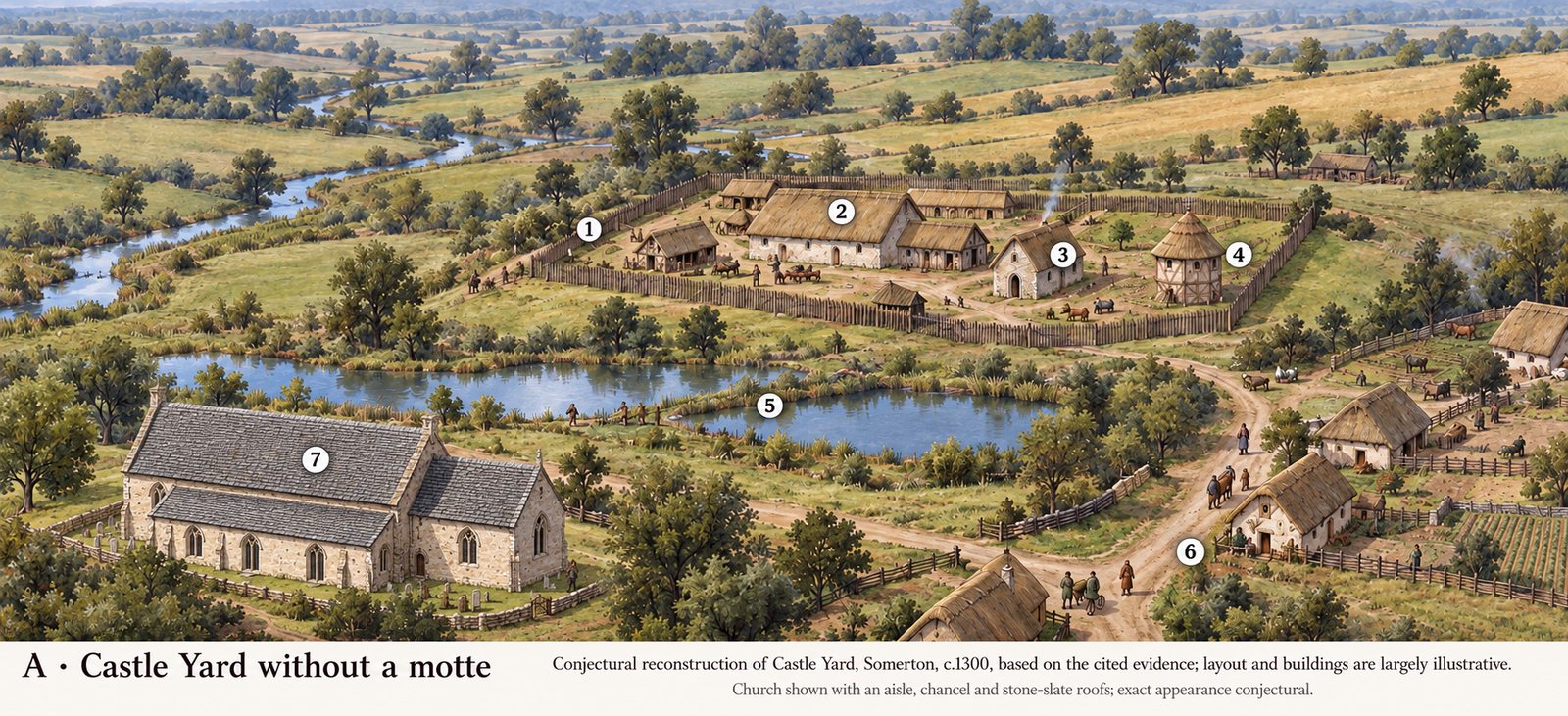
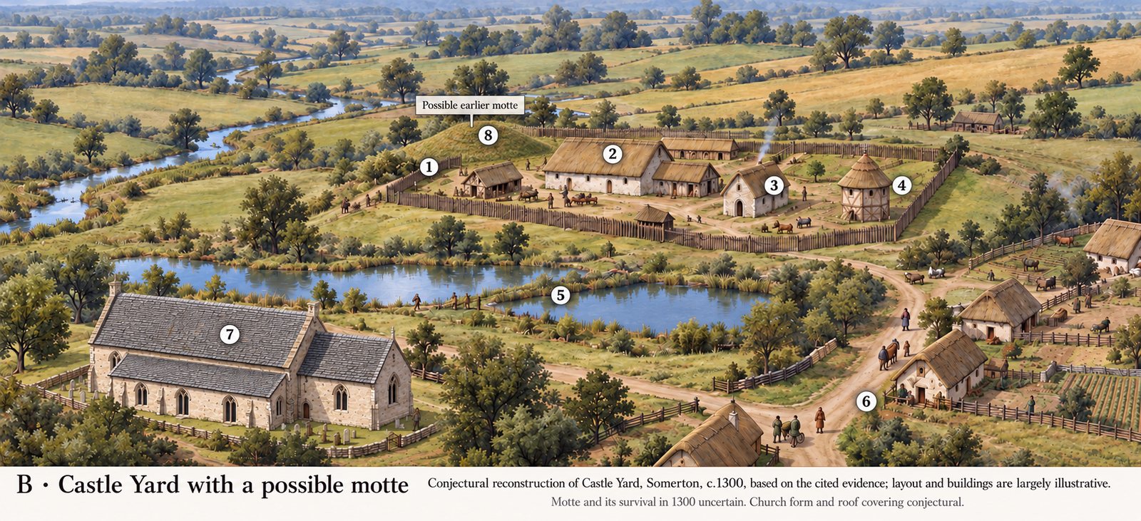
- Fence or wall round the yard (From the records). The archaeologist R. A. Chambers concluded it was “a simple walled or stockaded enclosure”. Its shape and size are Imagined. There was no water-filled moat: none was found when the ground was opened up in 1973.
- Hall and living quarters (From the records). Traces of stone buildings were found. Their layout is Imagined.
- Chapel (From the records). It was still standing in 1580, when Thomas Fermor left it to become the village school. The Old School House is said to stand on the spot.
- Dovecote (From the records). A dovecote is listed in a survey of 1295. Its shape is Imagined.
- Fishponds (Still there today). The pond earthworks can be seen in Rectory Close.
- Village lane and houses (Still there today). The sunken lane and house plots of this deserted corner of the village show clearly from the air. The houses themselves are Imagined.
- St James's church (Still there today, in part). The round Norman pillars and the chancel were already standing. The tower came later, so it is left out.
- The mound, picture B only (Imagined, but possible).
In the 19th century, several graves were found beneath a floor of the school building, (together with a silver cross which is now lost), and a further 12 shallow graves were discovered in the Castle Yard cemetery in 1953 and 1969. Some of these had a slab of limestone covering the skull which suggests they were Anglo-Saxon or early medieval burials, pointing to the existence of a settlement at Somerton before the Norman Conquest.
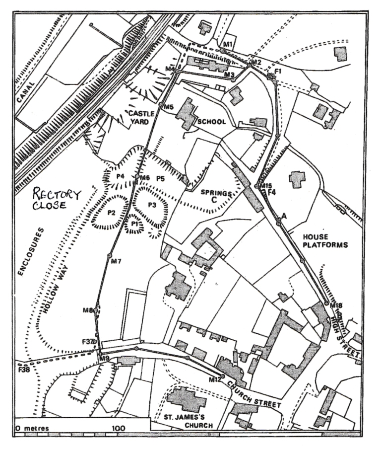
The above map shows the pipe trenches which were observed in 1973. The trench between M4 and M9 follows the line of the public footpath, which runs through Castle Yard, between the fishpond remains, to the lower end ofChurch Street.
R A Chambers’ full report can be seen at:-
http://oxoniensia.org/volumes/1977/chambers.pdf
New Research, 2026
Added October 2026. Each item below has been checked against the source named with it. Where only a transcript or a later account has been seen, that is said.
A gilded cross, found in two halves
Some time before 2012, two metal detectorists working several metres apart in Somerton parish each found half of the same object. The halves fit together exactly, which suggests it was broken fairly recently, probably by ploughing.
It is a cast copper-alloy cross, gilded front and back, with splayed arms decorated in chip-carved interlace. It dates from the eighth century and is in the Carolingian style. It was recorded as a brooch, but the fittings on the back could equally have held a cord, so it may have been a pendant. There is no direct parallel on the national finds database.
It tells us someone in or passing through Somerton owned a fine piece of metalwork twelve hundred years ago. It does not tell us who, or that there was a church here then.
A Viking-style brooch, a long way from home
A small Type I brooch in the Borre style, the decoration associated with Scandinavian settlers, has also been found at Somerton. Most brooches of this kind come from East Anglia and Lincolnshire, and the specialist report on finds for 2022 singles out the Somerton one as noteworthy because it is so far outside that area. Fashions travel. One brooch does not make a Viking settlement.
Roman pewter
The Portable Antiquities Scheme recorded a group of Roman pewter from Somerton in 2011, including an octagonal dish dated broadly to AD 332-410. It was published in the journal Britannia in 2012. Earlier accounts have described a larger service found in a burnt deposit near Mudginwell. We have not yet been able to check those details against the published report, so they are left out here for now.
Next to Dormer House
In 2013 an archaeological evaluation on land next to Dormer House, Ardley Road, found that the earliest activity began in the mid-eleventh century, when two buildings were put up with fronts on the same line. They were rebuilt or replaced into the thirteenth century. A limestone rubble house platform followed, occupied from the thirteenth century until probably the sixteenth, after which the site seems to have gone to pasture. The dig also turned up Iron Age and Roman pottery.
Less than 200 metres away, a watching brief at Somerfields, Heyford Road, in 2022 found only medieval pottery that had been moved about and possible surface layers of the fifteenth to eighteenth centuries. The two sites should not be confused.
Sources: Anni Byard, "The Portable Antiquities Scheme in Oxfordshire, 2011", Oxoniensia 77 (2012), p. 298 (PAS BERK-9FA163); "Medieval Britain and Ireland in 2022", Medieval Archaeology (PAS SUR-578B66); S. Worrell and J. Pearce, "Finds reported under the Portable Antiquities Scheme", Britannia 43 (2012), no. 17 (PAS BERK-C55677); Oxfordshire Historic Environment Record MOX26597 (John Moore Heritage Services, 2013); Oxfordshire HER MOX28337 (Archaeology Warwickshire, 2022).